|
| |
Here's my packing list:
| Clothing:
2 pairs cycling shorts
knickerbockers*
overpants*
gaiters!
2 sets thermal*
underwear
2 sets underwear
3 pair wool sox
wool cap*
casual pants
shirt (long sleeved)
2 jerseys
2p regular sox
rain jacket
hat (brown)
bandanna!
cycling gloves
wool gloves*
Ski Gloves!
helmet with mirror
"city" shoes
hiking shoes (for cycling)
|
Camping Gear:
small tent
ground sheet
sleeping bag
sleeping pad
sleeping cap!
trangia cooking set
mug, plate, spoon, chop stick
lighter
fuel bottles
spices
pocket knife
candle lantern!
flash light
pot scrubber |
First Aid Kit:
triangle bandage
tensor bandage
hydrocortisone cream
Sulfatrim (amoebas)
antihistamines
anti-nausea pills
Fansidar
imodium
alcohol pads
antiseptic ointment
thermometer
anti-fungus cream
analgesics (pain killer)
heat rub
gauze pads
bandages
adhesive tape
burn cream
sunscreen
toothache gel
lip balm
cough drops
IAMAT directory
iodine
insect repellent
Note: I had been vaccinated for Hepatitis A and B and for typhoid |
Personal Gear: tooth brush and paste
toilet paper
dental floss
nail clip
soap
laundry soap
towel
deodorant
razor and blades
watch with alarm feature
compass
map case
maps
diary, pen
camera
film(5 rolls)
glasses
spare glasses
sun glasses
binoculars
novel (The Voyage of the Beagle)*(I gave it away)
dictionary
grammar book! (replace with a small cheat sheet)
passport pouch
postcards from home
small rope
sewing kit
duct tape
ziplock bags |
| The list is not perfect and you may have reason to pack differently. Then,
I am a sucker for books and bought a bird book, and collected fliers, ticket stubs,
shells, rocks, plant leaves etc. which for me are essential souvenirs. When I got strict
with myself about reducing baggage weight, I had to send home the birdbook, clothing,
souvenirs collected up to this point and a full travel log book. Also, I would not take
any longer on the same trip (route and time of year) the items denoted by a !
I also sent some of the extreme weather gear (marked by *)
home by mail once I was out of the Tierra del Fuego: |

The list for the bike etc:
| Bike: bike
rear rack
front rack
front panniers
rear panniers
carry-on bag (8"x14"x20"), strapped across rear panniers
handle bar bag
lock
odometer
2 water bottles
bungee cords
photocopy of passport (in handle bars) |
Bike Tools: 6-inch adjustable wrench
8-9-10mm Y-wrench
allen keys to fit bike
spoke key
2 tire levers
leatherman’s tool
chain breaker
free-wheel remover
crank remover
cone wrench
grease in film container
drive-train oil
patch kit
|
Bike Parts: brake cable
derailleur cable
assorted bearings
assorted nuts and bolts
spare wire
2 folding tires
spare tubes
pump
5 spokes to fit front and rear |
| What I missed was a tool to remove the cogwheels at the real wheel when
a spoke on the right side broke. But I not sure it's worth taking when you got a more
suitable bike.
My bike is a Wheeler Crossline 2400, equipped as a hybrid
bike, with gripshift Shimano SRT 300I, 21 gears, Avocet Kevlar tires size 700x38C, fenders
for inevitable splash in the rain, rat traps on the pedals (straps removed, after a spill
where I could not extricate my foot fast enough). The panniers were made by Serratus, a Canadian manufacturer, and
bought from the Mountain Equipment Coop in Toronto - two
56-liter packs in the back and two 40-liter packs in front. A handlebar bag, also from
Serratus, and a carry-on bag from EuropeBound, with hidden straps, completed the packing
system.
With hindsight, I would no longer use a hybrid bike as it
is not strong enough for the gravel roads and the gravel. The tires should be wide, for
soft gravel. A hint: if you have a hard tire on gravel, it will sink down. Reduce the
pressure and it tends to float on top. I also recommend a suspension
system because the constant shocks from rocks in the road will wear out your
rear-end, arms and hands. Else, give yourself frequent breaks: pick berries, talk to
people, look at shells or trees, push up a hill instead of pedalling - be creative and use
it as an excuse to get to know more of the country. A word about
speed: if you have narrow tires, do not cycle faster than 15 km/hr on Patagonia's
gravel roads. In hindsight, the only two flat tires that I did get on this trip were both
the consequence of going too fast...
A problem in Patagonia are burrs that are abundant in the
weeds of the roadside: their seeds have prickles that are as sharp as cactus needles and
will give you an ugly surprise when you try to pick them off your socks. Worse, if you
ride over them, they will work into the tire and may puncture the inner tube. A thick tire
tread helps, and another excellent remedy is "slime", a green gooey stuff that
you inject into the tire via the valve. Pre-slime your tire at home; I had complications
when I tried it on the trip.
Plan for spare room in your packs that you will need when
you buy food (you'll need enough food to travel from one town to the next, and YES, you
don't know yet which way the wind will be blowing. Smile!) and when you carry extra water
on the really dry sections (read the trip reports of others that traveled there before).
The Serratus panniers were excellent: strong, practical
and reasonable water-resistant, I recommend them strongly. But I am not happy with the
packing system that is so common: it's great as long as you cycle. But when you want to
stop and hike in the mountains, it would be nice if could pack enough gear to be able to
stay overnight, leaving your bike and panniers behind. I fudged it with my carry-on bag
with the hidden straps, tying a lot of stuff to the outside because the bag is not big
enough. It made for an awkward pack. I wished there was a pack out there, small enough to
fit elegantly across the rear panniers when cycling, but expandable so that it holds all
the gear needed for back-packing when desired.
Good raingear is essential, and I used the Bernoulli
Gore-tex Jacket, also sold by the Mountain Equipment
Coop, and proved to be an excellent choice. I had rainpants which I used in the worst
weather. I also had Gore-tex socks but didn't bother after a while: they were too much
hassle and wool socks in the hiking boots was enough to give me comfort. When the rain was
bad, I wore a brown widebrimmed Tilley hat (OK, stop the laughing) and switched later
(when there was more traffic and less rain) to the helmet, mainly because that way I
had a mirror.
Other folks have done similar trips, in various areas of the globe, and to explore
their experience, click over to Ken Kifer's
Bike Pages. |
About Trip Planning:
 | The prevailing winds come from the north-west and blow to
the south-east. You'll notice that I traveled the wrong direction, but you also may notice
that I made up for this "oversight" by using a bus on some sections. If you
cycle into the wind, you may pedal all day long in first and second gear. On such a day, I
was proud to have covered 60 km. As the road winds, you may have wind from the side and
you'll be fighting to stay on that thin ribbon of ridable surface, with a harsh rocky
centre strip to your left and the soft grit towards the edge of the road.
Further, the wind will make noise and you may not hear the truck coming up from behind (it
happened to me - the truck stopped as I struggled in the wind and blocked his path).
|
| Distances between places are long in Patagonia. When you
see a place with a name on the map, do not assume it is a village or town, most of the
time it is the name of an estancia (sheep farm). You can ask there for water, but do not
expect to be able to buy anything there. Bring food enough to get you to the next place
that you know to have a store or restaurant.
|
| Water: Some areas (e.g. the southern half of Tierra del
Fuego) have water in creeks, and I was advised that, if there are trees on the slopes
above, it is drinkable. You realize that the country is full of livestock and where they
are, you should assume the water is polluted.
But in most areas, the creek beds are dry and you have to rely on human habitation for
water. Before entering a long stretch where you think there are farms, discuss this with
people that travel there. Some farms are on the map but they are abandoned. How's
your Spanish, by the way...?
|
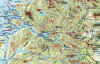
| Maps: The first two maps I bought were useless. The map
that was reasonably accurate and indicated gravel vs. paved roads correctly is:
Map #16 "Patagonia"
This map covers Patagonia (Chile and Argentina) from the Golfo
San Mat�as (near the Valdez Peninsula) southward and is of scale 1:3,000,000. On the back
is a detailed map of Chiloe.
Later, I discovered others:
Map #17 "Camino Austral - Patagonia Chilena"
At a scale of 1 : 1,100,000, this map covers the area from the Pacific coast to (including)
Rta 40 in Argentina, between 41� and 48� latitude, and thus includes Pto Montt, Chiloe,
Laguna San Rafael, Coyhaique, Chile Chico, Perito Moreno and Lago Belgrano. On its back is
a close-up of the area around Coyhaique. Not bad for someone thinking of pedalling the
Carretera Austral, or planning to visit Laguna San Rafael.
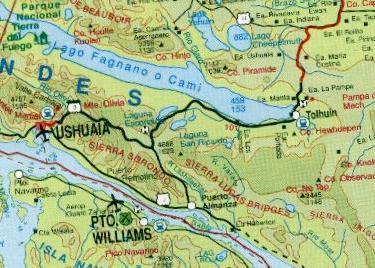
Map #18 "Patagonia Sur - Tierra del Fuego"
 This map continues south from Map #17 (but leaves a gap of
about 100 km - see below) and extends south to include all of Tierra del Fuego. Thus
covered are Lago Viedma, Torres del Paine and Pto Natales, Pto Santa Cruz and Cape Horn.
To get the best coverage with the least use of paper, the map does not point exactly
north, and the back has a large-scaled map that covers everything from Osorno (north of
Pto Montt) all the way to Cape Horn. As an added curiosity, there is a trekking map near
Pto Eden, the single stop-over of the ferry from Pto. Natales to Pto. Montt. The loop
there is listed as 4-5 days, and makes use of one ferry in the interior, and needs to be
accessed via a ferry in the fjords. This map continues south from Map #17 (but leaves a gap of
about 100 km - see below) and extends south to include all of Tierra del Fuego. Thus
covered are Lago Viedma, Torres del Paine and Pto Natales, Pto Santa Cruz and Cape Horn.
To get the best coverage with the least use of paper, the map does not point exactly
north, and the back has a large-scaled map that covers everything from Osorno (north of
Pto Montt) all the way to Cape Horn. As an added curiosity, there is a trekking map near
Pto Eden, the single stop-over of the ferry from Pto. Natales to Pto. Montt. The loop
there is listed as 4-5 days, and makes use of one ferry in the interior, and needs to be
accessed via a ferry in the fjords.
Another useful map is the detailed Torres del Paine
hiking map, Map #13, which is used by most hikers.
Then, there is a map of the southern Lake District in Chile (Trekking
Map "Rutas de Jesuitas", #15 by JLM Mapas), and includes Puerto
Montt; the Parque Nacional Alerce Andino; the volcanoes Osorno, Calbuco, Puntiagudo,
Tronador, and Puyehue; Bariloche and all Lago Nahuel Huapi (Argentina); Lago Puyehue; and
Osorno. It shows the usual geographic detail including contour lines, paved vs unpaved
roads, the major hiking trails (the Lonely Planet guide of Patagonia has more) and some
enlarged sections. It covers all the area of my loop from Osorno to
Bariloche and back to Puerto Montt.
You can order these maps from
http://www.chileaustral.com/shopping/maps.html.
I tried it in February 1999 and it worked well. The map was in the mail for 9 days,
which is great for mail from Chile. In comparison, mail from the US to Toronto takes five
days. Recently (Dec 2000), Maps 17 and 18 were sent to me by the folks of
Chileaustral for evaluation (Many thanks!). They took about 3 weeks to get through the
Christmas mail rush and clear Canadian customs.
The company that produces the maps is
JLM Cartografia
Gral. de Canto #105 of.1506
Fono/Fax 236 48 08
Providencia Santiago
Chile
|
| You will encounter tremendous hospitality and you must not
abuse it. Take enough food to last you to the next shop - make it a habit to receive any
gift (including meals) as a peer and not as a beggar. Have things handy to reciprocate the generosity. I thus parted with my Canada pin, a
headband, my best postcard of Toronto, and on several occasions packages of snack foods.
When people expressed interest, I described what it's like where I come from. For that
purpose, I had brought along about 15 postcards and photos from Toronto and my life back
there. Once home again, I wrote to several of the people I had met and expressed my
thanks. I bet you have good ideas of your own and can be creative!
|
| Property rights are very strong in Patagonia. As a guest,
it's not up to you to question the system: just ask before you cross a fence or camp on
what might be owned.
|
| Buses: When you want to skip long monotone and strenuous
sections, you could use a bus. I have experience only in Chile and you should not make the
assumption that things are the same in Argentina. First, familiarize yourself with the
various classes of bus transportation. The ones you want have storage underneath the
midsection, i.e. the buses between the bigger cities. ( I am not sure that Ushuaia is
served by such buses). Next, you have to find the bus terminal that services the route you
choose (a town may have several bus terminals): your hotel
or hospedaje staff will know. In Chile, the transportation system is private, i.e.
different companies compete and you can shop for best departure times and fares. Go there
the day before, check it out, indicate you have a bike to bring along and buy your ticket.
There is no charge for the bike, and you will have a fixed seat assigned to you. To get
the bike on, they ask you to remove the pedals, possibly wheels, and to turn the handlebar
sideways. If you have something to cover the greasy parts of the bike, i.e. a sheet of
plastic, they'll appreciate it. In Santiago, the fellow who loaded the bike expected a
tip: give it as everybody else does so too, and it might save you some damage from
whatever. Such tips were not common in the south: e.g. Puerto Montt and Punto Arenas.
A word of caution: the buses arrive at the "platform" about 15 min's before
departure and leave on the button - they don't wait.
|
|
Back to Trip Overview
|